Date and Location
Accident Date:
June 14, 2023Published:
July 26, 2023Zone or Region:
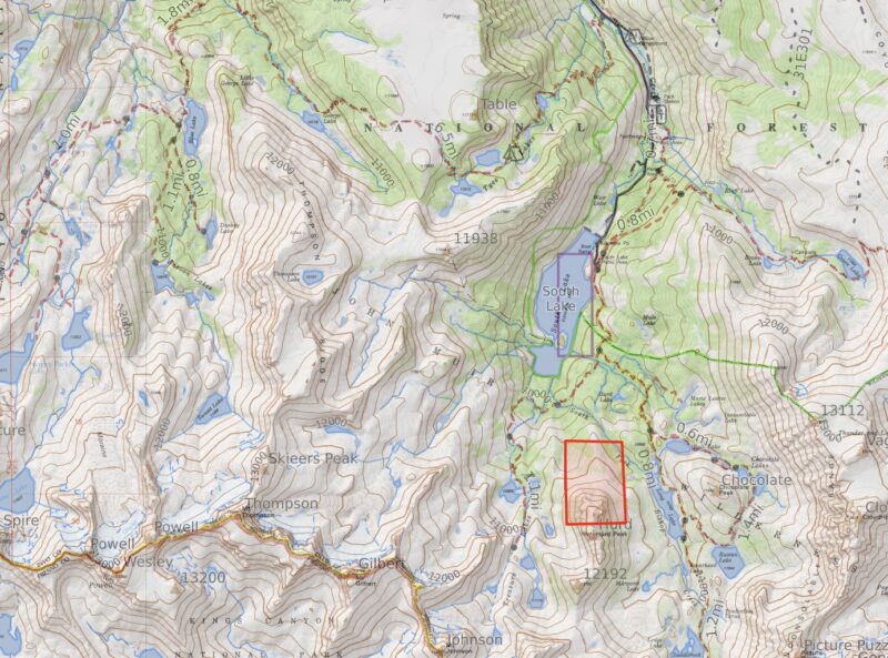
Bishop CreekLocation:
Hurd Peak - Avalanche AccidentAccident details
Elevation
11940 feetSlope Angle
42°Aspect
NEAvalanche Type
Wet LooseTrigger Type
NaturalSize Relative to Path
R1 - Very small, relative to pathDestructive Size
D1½ - Relatively harmless to peopleBed Surface
Within old snowWeak Layer
Old snowAvalanche length
895 feetAvalanche width
150 feetTerrain
Above Tree LineNumber Caught
2Number of fatalities
1Avalanche Description
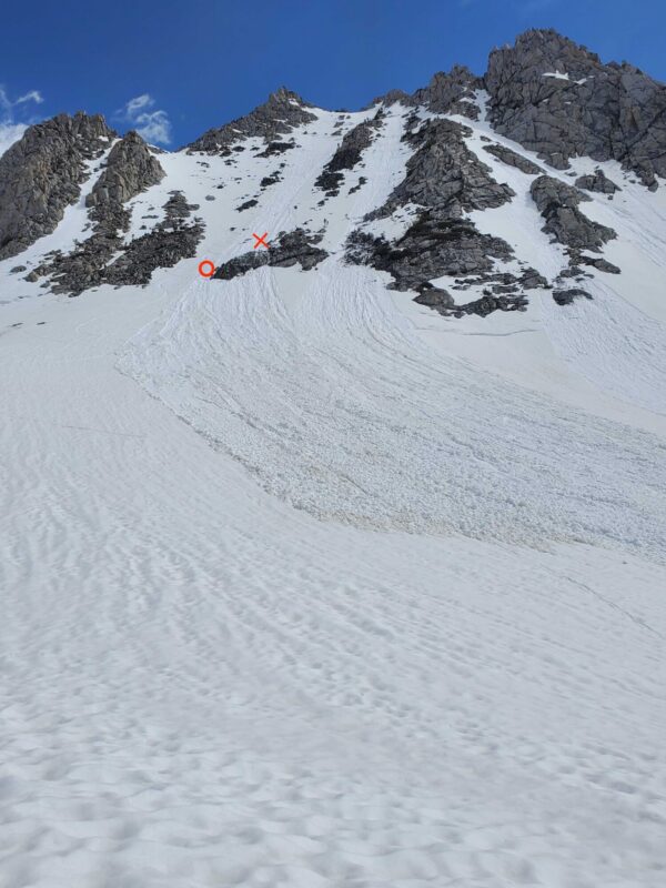
This was a naturally triggered wet loose avalanche. The avalanche was small relative to the path, with a destructive size of 1.5. The avalanche was likely triggered by a mass of melting snow falling from a rocky convexity onto the slope below. (WL-N-R1-D1.5-O). It started on a north-northeast-facing slope at around 11,940 ft and entrained wet snow in the start zone and track. 400’ lower, the avalanche struck a party of two ski mountaineers, carrying them downslope. Both skiers were partially buried and injured; one died due to injuries sustained during the avalanche. The debris was made up of round masses of wet snow up to 40 cm in diameter. The debris was 20 cm to 50 cm deep and covered an area that extended downhill 150 m and was 50 m wide.
Avalanche Forecast
The avalanche occurred within the forecast area of the Eastern Sierra Avalanche Center, which issued daily avalanche forecasts during the 2022-23 season from December 4th to April 29th. ESAC’s final forecast product, a General Avalanche Information advisory, expired on June 1st – two weeks prior to the accident.
Weather Summary
From the end of May to early June, the South Lake weather station, located 1.6 miles north of the accident site at 9600’, recorded daily maximum temperatures in the high 50 °s to low 60 °s F and daily minimum temperatures in the high 20 °s to low 30°’s F.
Beginning on June 10th, a wet weather pattern characterized by afternoon moisture build-up and localized mountain showers entered the area. Precipitation mostly fell as rain. Regionally no more than a few inches of new snow accumulated even at the highest elevations. At the South Lake station, .1 inches of rain was recorded on June 10th, with a further .1 on June 11th. At Mammoth Mountain, significant rain was recorded on June 11th (.68 inches), June 12th (.38 inches), and June 13th (.27 inches). It is difficult to extrapolate weather station precipitation data for this time period to the start zone on Hurd Peak because storms were localized, and even adjacent mountains may have had different precipitation quantities and type during this series of afternoon storms.
In the 24 hours preceding the accident, the South Lake weather station recorded a maximum temperature of 61° F and a daily minimum temperature of 36° F. There was scattered cloud cover and light south winds. No precipitation was recorded.
Snowpack Summary
The Eastern Sierra received record snowfall in the winter and spring of the 2022-23 season. The deep snowpack finally began its spring transition with a pronounced shed cycle and widespread wet loose avalanche activity on April 10th. Another warm-up, April 28th to 30th, caused a significant wet avalanche cycle, including isolated wet slab activity. By June, the transition to an isothermal summer snowpack was mostly complete, but with more than usual snow coverage and depth.
On the slope where the accident occurred, the snowpack was isothermal with variable depth, interrupted by exposed rock features. In the weeks leading up to the accident and on the day of the accident itself, an established boot pack was visible on the face. Public trip reports from the week before the wet weather showed consistent, supportable riding on melt forms (corn snow).
On the morning of the accident, a solo skier climbed and descended the face at approximately 9:00 AM, observing signs of impending wet snow instability. This skier reported wet surface snow and deep boot penetration on the climb and subsequently triggered a small wet loose avalanche at the top of the path. He carefully descended the bed surface. The skier did not see the second party that would eventually be involved in the accident which occurred later that morning.
Accident Summary
On the morning of June 14th, 2023, a party of two was ascending the north side of Hurd Peak when they began to notice signs of instability. Skier 2 reported that they discussed the deteriorating conditions and the possibility of turning around. Soon after this discussion, a natural wet loose avalanche released above the party and swept both individuals down the slope. As the avalanche ran downhill, Skier 1 was carried over a cliff band, and both parties were partially buried. After freeing themselves, Skier 2 was able to locate and extract Skier 1 and initiate Search and Rescue.
Rescue Summary
After coming to rest, Skier 2 had a hand free and was able to clear their face, dig themselves out, and initiate a search for Skier 1. Skier 1 was partially buried with a leg exposed, and Skier 2 was able to locate and extract them quickly. After assessing Skier 1’s condition, Skier 2 initiated search and rescue via their In-Reach device at approximately 11:45 AM. Skier 1 sustained critical injuries during the avalanche, and their condition deteriorated with time. The rescue was further complicated by continued avalanche threat. At one point during a subsequent avalanche, Skier 2 was forced to retreat from the toe of the debris to nearby safety before returning to uncover Skier 1 a second time. Inyo County Search and Rescue arrived on the scene mid-afternoon and was able to airlift Skier 1 to the hospital. Unfortunately, despite the heroic efforts of Skier 2 and the Search and Rescue team, Skier 1 did not survive their injuries.
Forecaster Comments
Avalanche accidents that result in serious injury or death are all devastating events, and we at ESAC extend our sincere condolences to the friends and family of the deceased and all of those affected by this tragedy. We offer the following comments in the hope that they will help people avoid future avalanche accidents.
This season’s record-breaking snowfall and abnormally cold spring led to substantial coverage lasting well into the summer months. This allowed for better-than-usual access for backcountry skiers and riders. However, it also meant that the snowpack had been subjected to somewhat atypical weather inputs, including intense solar radiation, summer rain and snow showers, and very warm overnight temperatures. This event is a tragic reminder that the snowpack remains dynamic and destructive avalanches are still possible during the spring and summer months.
Overnight temperatures measured at the South Lake weather plot (9,600’) near the site of this incident remained near or above freezing for several days leading up to this accident. Increased daylight hours during early summer and the slight eastern tilt of this slope results in the north face of Hurd Peak receiving solar input shortly after sunrise. The shallow nature of this slope and exposed rock features encourage rapid warming while inhibiting overnight radiational cooling. Cloud cover present on the evening of June 13th may have also added a green housing effect, limiting the overnight refreeze potential. It is also important to note that the snow on the approach and lower flanks of the north face have a northwest aspect and are partially protected from the morning sun by surrounding terrain. Snow in the upper start zone warms more quickly than snow along the approach. This means that the first signs of instability may not be observed until fully exposed to overhead hazards.
This accident is a tragic reminder that conditions can change dramatically from one day to the next and that even a relatively small avalanche can have devastating consequences in steep and rocky terrain.
Media


