Date and Location
Accident Date:
January 12, 2024Published:
January 15, 2024Zone or Region:
Mammoth LakesLocation:
San Joaquin RidgeAccident details
Elevation
9600 feetSlope Angle
40°Aspect
NEAvalanche Type
Soft SlabTrigger Type
Artificial - SkierSize Relative to Path
R3 - Medium, relative to pathDestructive Size
D2 - Could bury, injure, or kill a personBed Surface
GroundAverage Crown Height
3 feetWeak Layer
Old snowAvalanche length
900 feetAvalanche width
450 feetTerrain
Near Tree LineNumber Caught
1Number Buried
1Avalanche Description
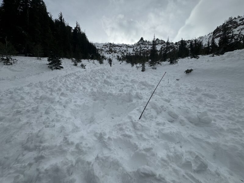
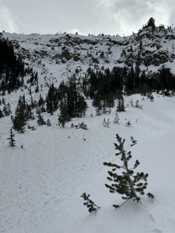
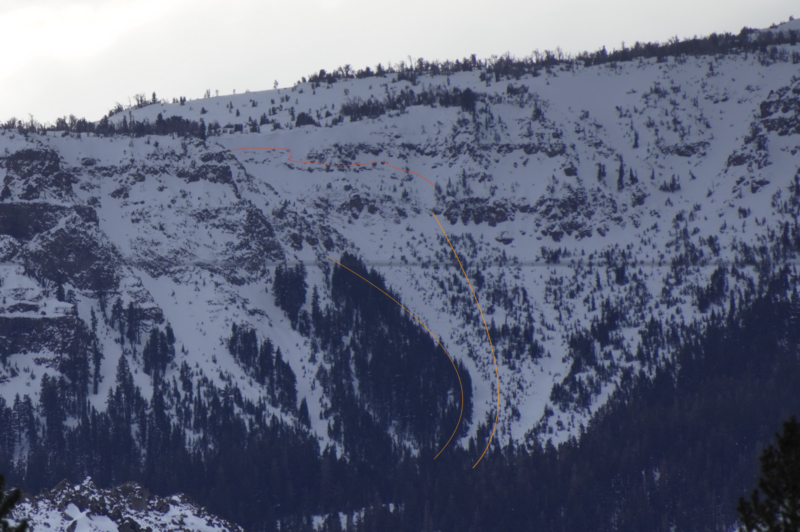
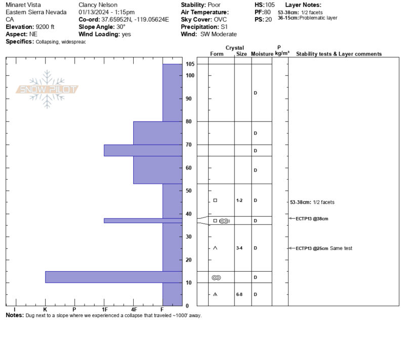
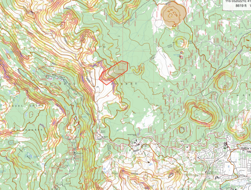
This avalanche was triggered by the second skier on the slope, was medium relative to the path, and had a destructive size large enough to injure, bury, and kill a person (SS-ASu-R3-D2-O). It started on a north-northeast-facing slope at around 9,600 feet and propagated a long distance across the slope, stepping down from a mid-pack facet layer to depth hoar near the ground. A storm event on the 13th of January prevented ESAC staff from conducting a full site investigation. However, estimates from photos, maps, and an interview with the party suggest the crown height of this avalanche ranged from 2-4 ft and had a width of around 450 feet. This avalanche initiated at around 9,400’ and ran for about 1,500 feet in length and 1000 vertical feet in below treeline terrain.
Avalanche Forecast
For the full forecast, please follow this link
On the day of the incident, the Eastern Sierra Avalanche Center rated the avalanche danger as Moderate (Level 2) at all elevations. The forecast listed Persistent Slab avalanches as the primary problem at all elevations on northwest through north to east facing slopes. The likelihood of triggering was possible, and the potential size was small (D1.5) to large (up to D2.5). The summary statement read:
“Weak layers of sugary snow are responsible for shooting cracks, collapsing, and some recent avalanches at all elevations. In some areas, the feedback from these layers has been widespread and obvious, especially on north and east-facing slopes between Mammoth and June. In other places, you may not get signs of instability until you’ve wandered onto the wrong slope. Persistent slab avalanches can be triggered from low-angle terrain below or adjacent to avalanche starting zones. Once triggered, these avalanches often break in unexpected ways and could involve the full depth of the snowpack. Careful route selection and evaluation are important strategies to manage this problem. When in doubt, choose travel routes with lower slope angles and without exposure to overhead hazards.”
Weather Summary
The Eastern Sierra Avalanche Center measures snow and snow water equivalent (SWE) at the Sesame study plot located at and maintained by Mammoth Mountain. This study plot is located about 1.6 miles to the southeast of the site of the incident at a similar elevation. The Mammoth area was impacted by a winter storm in the days preceding this event. On the evening of January 10th, 14 inches of snow and 1.3 inches of SWE were recorded at the Sesame Study plot. This snow was accompanied by strong to extreme winds out of the southwest. Temperatures remained below freezing for the entirety of this storm as well as the days preceding the event.
Winds recorded on Mammoth Mountain were predominantly out of the southwest for the entirety of the storm and reached speeds well over 100 mph at all elevations during the storm on the 10th. On the Day of the incident, ridge-top winds recorded on the summit of Mammoth Mountian were strong out of the south, with a peak gust of 58 mph.
Snowpack Summary
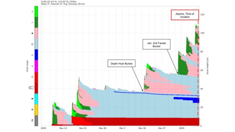
The early season in the Eastern Sierra was marked by a few small, relatively warm precipitation events and long periods of cold and dry weather. A total of 27” of snow (5.35” SWE) were recorded at the base of Mammoth Mountain by the end of December. This meager start to winter led to intermittent snow coverage across the forecast area. While many solar aspects and windward slopes were returned to bare ground, many shaded aspects, particularly in the Mammoth region, held on to decent snow coverage. This entire snowpack saw extensive faceting throughout November and December, but most concerning to the forecast team was the presence of large depth hoar grains, averaging 4-8mm in size and 10-30 cm thick, near the ground. In general, at elevations above 9,500’, this layer of depth hoar was resting directly on the ground, while below 9,500’, this concerning layer was above a relatively thick rain crust.
In early January, we saw a change in pattern with the first major loading event of the season when 15” of snow (1.3” SWE) were recorded over a two-day period on January 2nd and 3rd. This storm was followed by 9.5” of snow (1” SWE) on January 6thth. These storms effectively created our slab, expanding our persistent slab problem beyond terrain features with wind-stiffened surface snow and leading to a sharp increase in avalanche activity. During this time frame the forecast team began tracking on a second persistent weak layer of buried near surface facets at the January 2nd interface. On the evening of January 10th, two days prior to this incident, 14” of snow (1.3” SWE) were recorded in the area, and this storm was accompanied by strong to extreme winds.
Terrain characteristics in the start zone of this avalanche are such that this slope receives very little sun in the winter months. This slope is also oriented on the leeward side of a low ridge, which encourages deposition by our prevailing winds. These factors led to more substantial coverage in this area, which may have made it attractive for skiers. However, shaded terrain like this encourages faceting and allows for weak snow to persist through the weeks of dryer weather. In addition, this terrain is broken by large boulders, small trees, and cliff bands, which further encourage faceting.
Accident Summary
A party of 2 left the Main lodge parking lot at Mammoth Mountain at 11:30 am on January 12th and made their way up the Minaret Vista road towards the San Joaquin ridge. As part of their pre-trip planning process, they discussed both avalanche problems for the day, Persistent slabs and Wind slabs, and notably, they focused much of their conversation on recent control results at Mammoth Mountain. On January 11th, the day before the accident, ski patrol initiated numerous D2-D2.5 persistent slab avalanches on basal facets near and above treeline. They also reported feeling some time pressure as they had arranged to meet friends at Mammoth Mountain later that afternoon.
Skier 1 had been to the San Joaquin area serval times previously this season. In previous visits, they had spent time investigating the snowpack and were aware of the complex snowpack structure. During one of these previous visits, they identified their chosen descent as a goal. This was the first visit to the area by Skier 2.
Along their approach to the slope, they noted less fresh wind slab development than they had anticipated and took this as a positive sign. After arriving at the chosen descent both skiers took the time to get eyes on the slope from different angles and discussed briefly the plan for descent. The slope they chose to descend is a steep, northeast-facing chute-like feature with a large rock outcropping on the skiers’ right and a broad, shallow slope punctuated by cliff bands and rollovers on the skiers’ left. The main chute of the line bends to the right as it moves down the slope and splits into two distinct gully features separated by a sparsely treed moraine feature. They chose to descend 1 at a time and discussed the point where they would regroup at the bottom. Skier 1 made it to the bottom of the slope without incident.
Skier 2 was not able to see Skier 1 when they entered the slope. Skier 2 chose to ski slightly to the left of Skier 1’s tracks and triggered the avalanche on their third turn. Skier 2 was caught, carried, and fully buried in this avalanche.
Rescue Summary
Skier 1 reported reaching the bottom of their descent and, within 2-5 seconds hearing a buzz. They turned up the slope and saw the avalanche coming towards them. Initially, they began moving further down the slope, retreating from the avalanche, and felt the powder cloud. After confirming the avalanche had settled, they immediately called Skier 2 on the phone with no response. Skier 1 was able to initiate search and rescue, transition to skins, and locate, uncover, and clear Skier 2’s airway in around 10 min. After conducting an initial medical assessment, both skiers were able to move out of the avalanche path and conduct a more thorough medical assessment. At this point, they called off outside resources and were able to make their way to the road under their own power. After reaching the highway, skier 2 was transported to the hospital and evaluated for their injuries.
Forecaster Comments
Avalanche incidents are scary and often tragic events. It takes courage and humility to relive these events, and it’s not always clear where or if mistakes were made. We want to thank those involved for their honesty and willingness to share their story so that others can learn.
The 2023/24 Season got off to a slow start in the Eastern Sierra, creating atypical and challenging conditions. Managing a prolonged persistent slab problem like this is not something backcountry skiers and riders are used to in this region. Adding complexity to the situation was the intermittent and shallow snow coverage during the early season. Areas that had coverage and were attractive for skiers and riders were the same places where the problem existed. Furthermore, storms over the days preceding this accident were a tipping point of sorts. Strong winds and new snow added cohesion to the upper snowpack, connecting start zones with a continuous, cohesive slab.
The party reported that time pressure may have led to some shortcuts during their assessments. While they did survey for fresh surface instabilities, they did not dig to assess for the presence of basal weak layers. In addition, while they carried radios, they neglected to turn them on, which limited their ability to communicate while out of sight and earshot. It is unknown whether or not a change in these factors would have led to a different outcome.
This incident only resulted in minor injuries to the buried party thanks to the heroic efforts of Skier 1 to perform a speedy and effective rescue.
Media
